Worth noting for #GoogleMaps users...
-
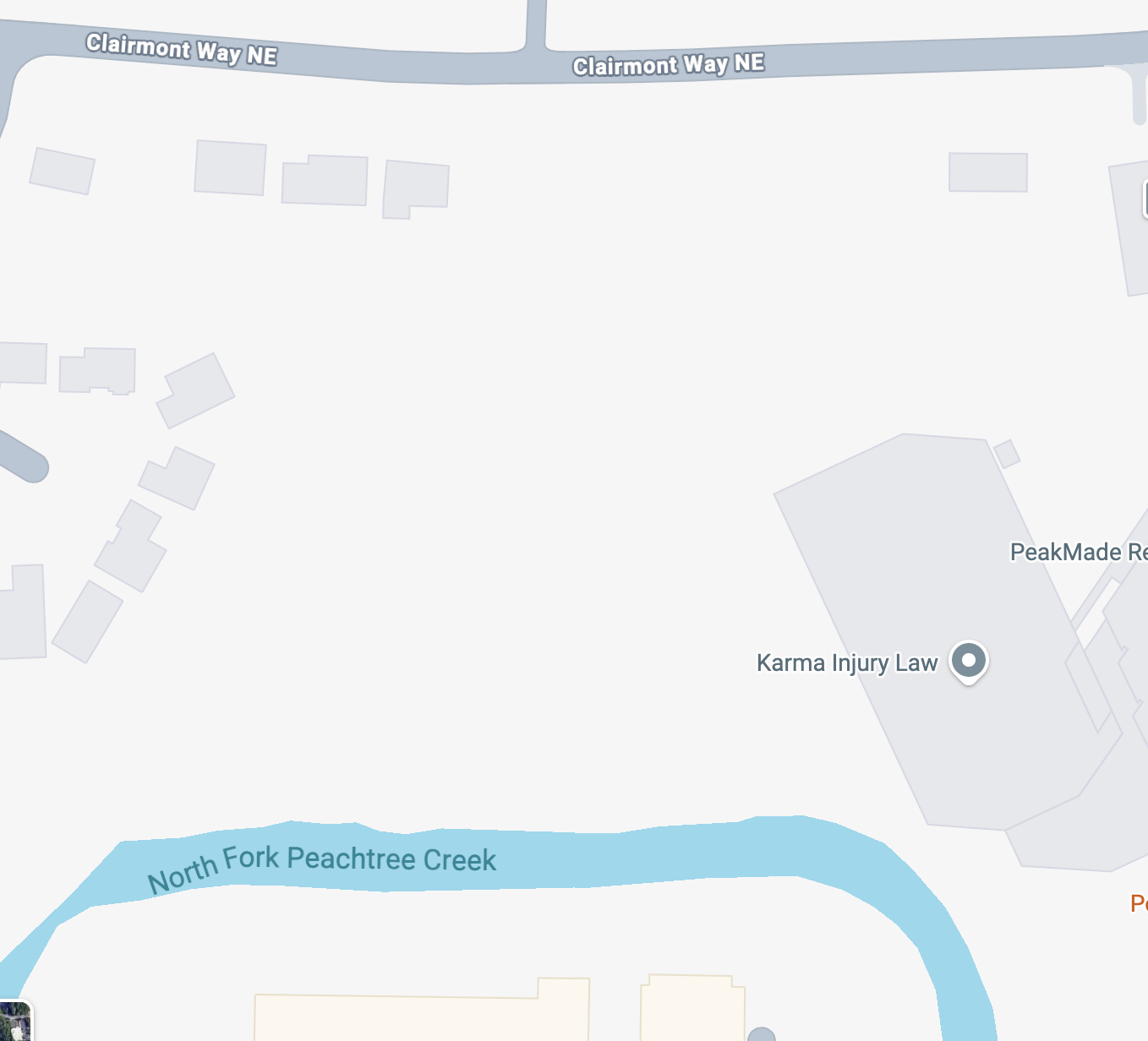
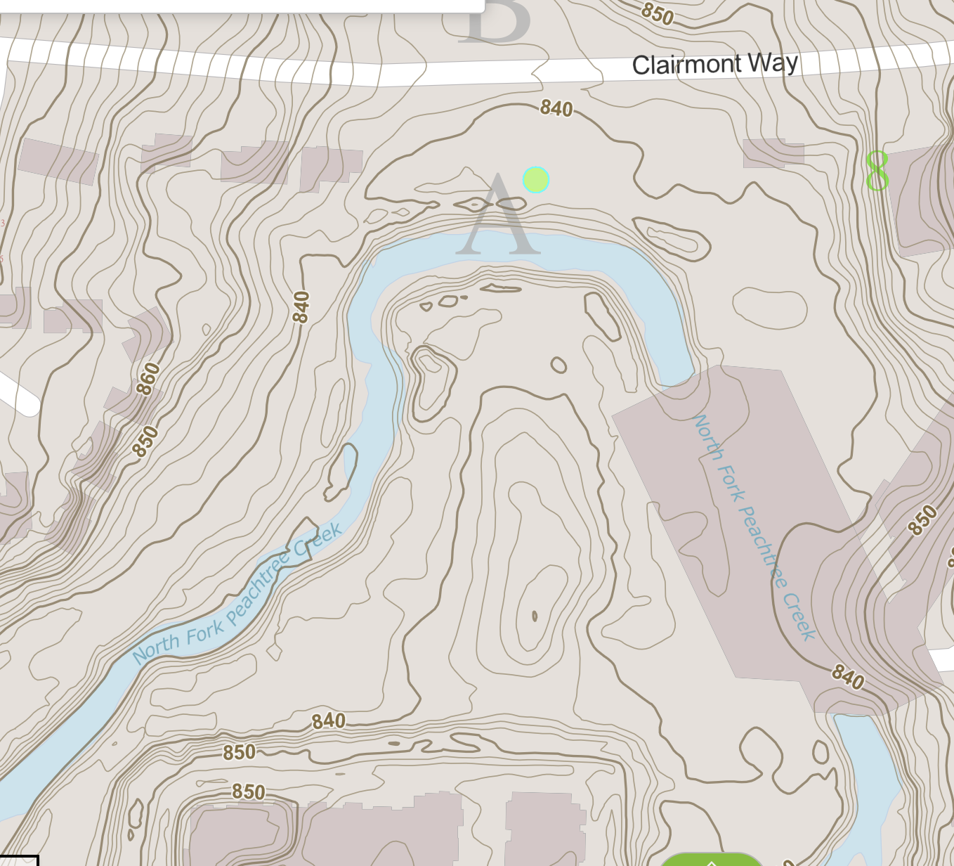
Worth noting for #GoogleMaps users... It has been clear to me for some time that #Google is using machine learning algorithms (sometimes called "AI") to adjust boundaries of geographic features. I assume they run an #ML model over satellite photos to do this. Here's a example of it failing, badly. The first picture attached is a Google Map of an urban creek in my town, with a street just north of it. Note how Google shows the creek not going anywhere near the street. The second picture is a topographic map of the same area. Notice how the creek ACTUALLY goes much farther north than Google depicts. For creeks and bodies of water I've noticed this most often happens where there is an adjacent #FloodPlain that the creek spills into on occasion. Clearly Google's algorithm is noticing water during flood conditions, or breaks in the tree line, and "learning" that the creek has moved. (In their defense, it is quite unusual that this urban creek passes directly under an office building parking deck, which probably also played a part. But why use ML to do this stuff when #topographic data exists?) #AIFails #AIFailures
-
Worth noting for #GoogleMaps users... It has been clear to me for some time that #Google is using machine learning algorithms (sometimes called "AI") to adjust boundaries of geographic features. I assume they run an #ML model over satellite photos to do this. Here's a example of it failing, badly. The first picture attached is a Google Map of an urban creek in my town, with a street just north of it. Note how Google shows the creek not going anywhere near the street. The second picture is a topographic map of the same area. Notice how the creek ACTUALLY goes much farther north than Google depicts. For creeks and bodies of water I've noticed this most often happens where there is an adjacent #FloodPlain that the creek spills into on occasion. Clearly Google's algorithm is noticing water during flood conditions, or breaks in the tree line, and "learning" that the creek has moved. (In their defense, it is quite unusual that this urban creek passes directly under an office building parking deck, which probably also played a part. But why use ML to do this stuff when #topographic data exists?) #AIFails #AIFailures
@krelnik umm useful observation, thanks for sharing, off to check stuff locally!!
-
Worth noting for #GoogleMaps users... It has been clear to me for some time that #Google is using machine learning algorithms (sometimes called "AI") to adjust boundaries of geographic features. I assume they run an #ML model over satellite photos to do this. Here's a example of it failing, badly. The first picture attached is a Google Map of an urban creek in my town, with a street just north of it. Note how Google shows the creek not going anywhere near the street. The second picture is a topographic map of the same area. Notice how the creek ACTUALLY goes much farther north than Google depicts. For creeks and bodies of water I've noticed this most often happens where there is an adjacent #FloodPlain that the creek spills into on occasion. Clearly Google's algorithm is noticing water during flood conditions, or breaks in the tree line, and "learning" that the creek has moved. (In their defense, it is quite unusual that this urban creek passes directly under an office building parking deck, which probably also played a part. But why use ML to do this stuff when #topographic data exists?) #AIFails #AIFailures
What an insane decision. I have to use gmaps for work and even basic routing has started to not make sense.
-
Worth noting for #GoogleMaps users... It has been clear to me for some time that #Google is using machine learning algorithms (sometimes called "AI") to adjust boundaries of geographic features. I assume they run an #ML model over satellite photos to do this. Here's a example of it failing, badly. The first picture attached is a Google Map of an urban creek in my town, with a street just north of it. Note how Google shows the creek not going anywhere near the street. The second picture is a topographic map of the same area. Notice how the creek ACTUALLY goes much farther north than Google depicts. For creeks and bodies of water I've noticed this most often happens where there is an adjacent #FloodPlain that the creek spills into on occasion. Clearly Google's algorithm is noticing water during flood conditions, or breaks in the tree line, and "learning" that the creek has moved. (In their defense, it is quite unusual that this urban creek passes directly under an office building parking deck, which probably also played a part. But why use ML to do this stuff when #topographic data exists?) #AIFails #AIFailures
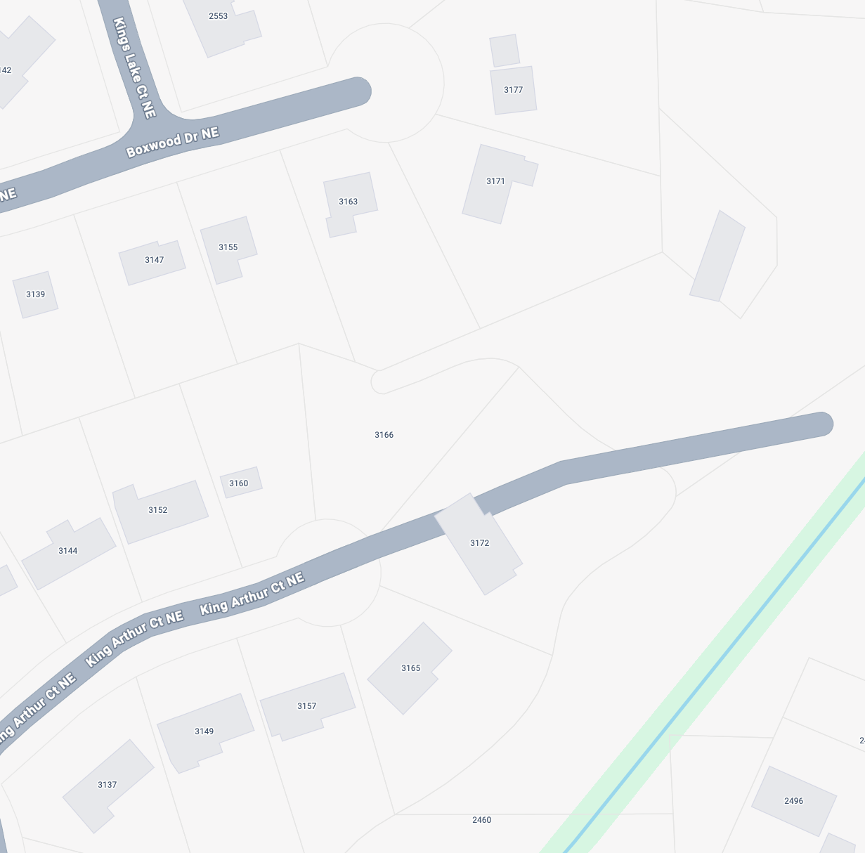
Here's another example of #Google algorithmically (I presume) updating maps in ridiculous ways. I don't even need to show an A/B diagram for this one. Here they have picked up on the driveway of a house on the end of a cul-de-sac, and inexplicably decided to extend street THROUGH the house and far beyond it into the woods. Among the many things their algorithms don't understand is yes, there are sometimes wooded areas between houses that just don't have a street to access them. (Very common in tree-heavy #ATLanta where I live). They clearly have data on the property lines and where the houses are, how do they think this street is like this? #ML #BadAI #GoogleMaps #Enshittification
-
R relay@relay.infosec.exchange shared this topic
-
Worth noting for #GoogleMaps users... It has been clear to me for some time that #Google is using machine learning algorithms (sometimes called "AI") to adjust boundaries of geographic features. I assume they run an #ML model over satellite photos to do this. Here's a example of it failing, badly. The first picture attached is a Google Map of an urban creek in my town, with a street just north of it. Note how Google shows the creek not going anywhere near the street. The second picture is a topographic map of the same area. Notice how the creek ACTUALLY goes much farther north than Google depicts. For creeks and bodies of water I've noticed this most often happens where there is an adjacent #FloodPlain that the creek spills into on occasion. Clearly Google's algorithm is noticing water during flood conditions, or breaks in the tree line, and "learning" that the creek has moved. (In their defense, it is quite unusual that this urban creek passes directly under an office building parking deck, which probably also played a part. But why use ML to do this stuff when #topographic data exists?) #AIFails #AIFailures
Oh what the fuck